

Disputed Thai-Cambodian Border Still Tense Despite Ceasefire
Fighting between Thailand and Cambodia stopped after five days of clashes in July that left dozens dead, according to Nikkei Asia.
ASEAN hopes to formalize a broader ceasefire at its Oct. 26 summit in Kuala Lumpur, to be witnessed by U.S. President Donald Trump. But tensions along the border remain unresolved.
In Thailand’s Sa Kaeo province, hundreds of Cambodians ignored an order to leave Ban Nong Ya Kaeo and Ban Nong Chan — two contested villages where Thai forces demolished Cambodian checkpoints in July. The sites are now fenced with razor wire and monitored by floodlights and CCTV, but the Thai military has not enforced the eviction. “That is the governor’s deadline, but we have our own,” a senior Thai army officer told Nikkei Asia.
The border dispute traces back more than a century. The “Siamese-Cambodian border was [partly] demarcated based on the watershed as indicated in a map sketched in 1904 by the supposed ‘joint committee’ consisting of Siamese and French surveyors,” Thai historian Charnvit Kasetsiri wrote in Preah Vihear. The authors noted that “Siam did not protest the map. In fact, during King Vajiravudh’s reign (1910–1926), a French map was even reproduced as the official map of Siam.”
Cambodia later brought the matter before the International Court of Justice in the 1960s over the temple known as Khao Phra Viharn in Thailand and Prasat Preah Vihear in Cambodia. The ruling favored Phnom Penh, leaving Bangkok wary of international arbitration ever since.
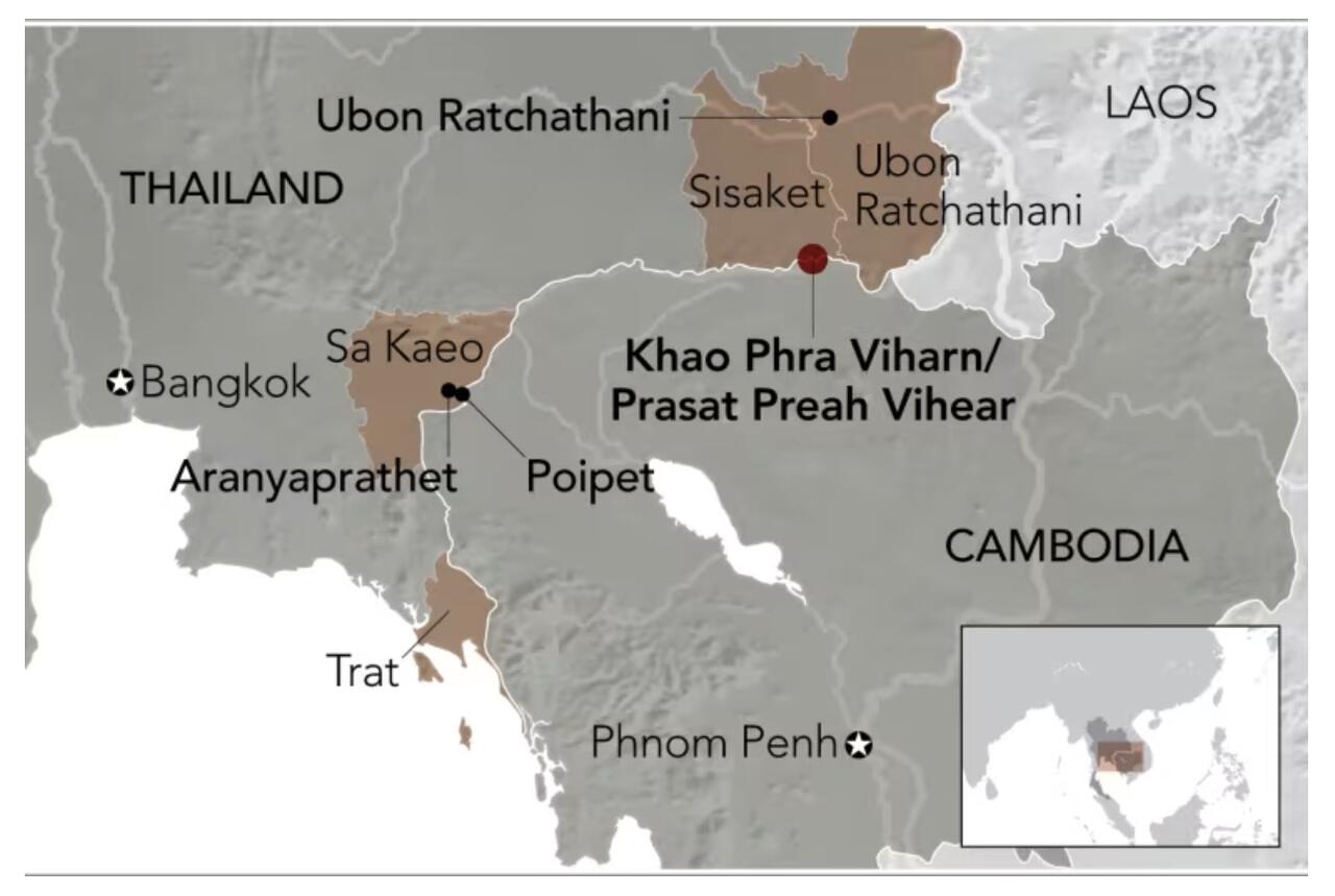
The 817-kilometer border remains only partly defined. Of 73 French-era markers, several are missing or contested. In Ta Phraya district, only the locations of markers 32 and 37 are agreed upon; 33 to 36 are still disputed, and one is missing entirely.
Nikkei writes that mapping discrepancies continue to complicate demarcation. Thailand uses a 1:50,000-scale chart, while Cambodia relies on a 1:200,000 version. “A millimeter could mean three to four kilometers,” said historian Thongchai Winichakul, author of Siam Mapped. “And the two maps are not compatible because [of] their methodology.”
Maj. Gen. Winthai Suwaree, spokesperson for the Royal Thai Army, defended Thailand’s map as “more accurate than the 1:200,000 map. We can see it from aerial photos,” he told Nikkei. “Originally there were no inhabitants. More people have gradually moved in every year, and so we must get serious about it.”
The main trade gate between Aranyaprathet and Cambodia’s Poipet, closed in July, is not expected to reopen this year.
Former Thai foreign minister Tej Bunnag wrote in a 2020 memoir that “our border must be scientifically demarcated from the Gulf [of Thailand] to Ubon Ratchathani,” adding that locating markers in Trat province would allow both countries to “negotiate how to share the natural gas off the Thai-Cambodian coast — as we did with Malaysia.”
Progress has stalled amid political caution and rising nationalism. “Right now, as long as both sides like to claim so much unrealistically, and don’t observe scientific facts, the best solution is just to sit tight and do nothing,” Thongchai said. “Many border demarcation committees around Thailand use that tactic […] because scientifically you can solve it, but politically you cannot. The crazy thing is that I think that’s smart.”
Tyler Durden
Sun, 10/19/2025 – 22:45ZeroHedge NewsRead More


 R1
R1
 T1
T1


