US Northeast Set For Post-Christmas Winter Storm
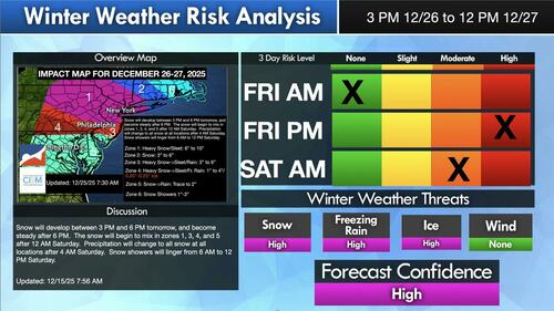
A post-Christmas Day winter blast is expected for parts of the Mid-Atlantic and Northeast for the end of the week, with some of the heaviest snowfall expected in eastern Pennsylvania, New Jersey, and the New York City area.
Meteorologist Steven DiMartino of private forecaster NY NJ PA Weather wrote in a new report Thursday that the winter storm will dump accumulating snow across the Mid-Atlantic and Northeast from Friday afternoon through Saturday.
Here is DiMartino’s forecast, which suggests that travel disruptions could occur up and down the I-95 corridor from Philadelphia to Boston:
-
Timing: Snow develops Friday between 3-6 PM, becomes steady after 6 PM. Mixed precipitation develops after midnight in several zones, with a change back to all snow by early Saturday morning. Snow showers may linger through late Saturday morning.
-
Heaviest impacts: Interior parts of New York and nearby areas could see 6-10 inches of snow or sleet.
-
Moderate snow: Portions of southern New England and nearby regions may receive 3-6 inches.
-
Mixed precipitation zones: Areas around Philadelphia and central Pennsylvania face snow changing to sleet or rain, with 1-4 inches of snow and up to .05-.25 inches of ice, raising the risk of slick roads and power issues.
-
Farther south: Snow may briefly change to rain, with lighter accumulations.
-
Coastal New England: Lighter snow showers, generally 1-3 inches.
Forecast Map:
Related:
Meanwhile, on the US West Coast:
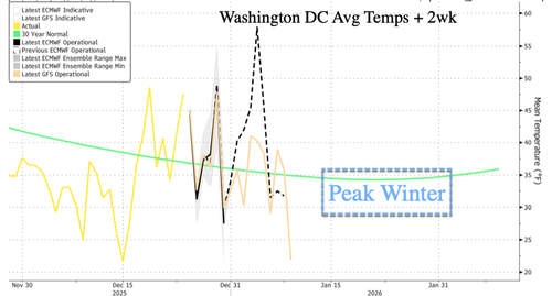
The latest warmup has been a welcome relief following a first half of December marked by polar vortex mayhem across the eastern half of the Lower 48.
We expect cold air to return in the coming weeks, as peak winter is between mid- and late January.
Tyler Durden
Thu, 12/25/2025 – 20:15ZeroHedge NewsRead More


 R1
R1
 T1
T1


