Stratospheric Warming Sparks Goldman Warning Of Looming U.S. Polar Vortex
We began this week by publishing a weather note on the latest weather models, warning of an incoming winter cold blast that will sweep across parts of the Lower 48 during the holiday Thanksgiving week.
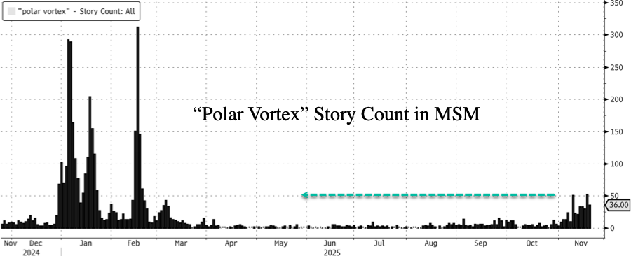
You might have noticed that the term “polar vortex” has been popping up across the news cycle in recent days, with headline volume (via Bloomberg data) surging to its highest level since early March as another cold blast is expected across the eastern U.S.
MSM headlines include:
-
CNN: The polar vortex is about to bring a wild weather pattern change
-
The Washington Post: An unusual phenomenon is likely to cause a frigid December in the U.S.
The incoming cold blast has even caught the attention of Goldman analyst Ranald Falconer, who informed clients about the incoming Arctic blast across the eastern and central U.S. for the next two weeks:
On the gas and PMI power front, Henry Hub sold off into the close yesterday but rallying again now; the EIA gas storage numbers showed the first of the winter withdrawals {DOENUSCH Index}. Weather fronts look to be keeping cold air across almost all of the east and central/south U.S. states for the next 14 days. I would expect that to be part of the reason we have seen a $20 move in peak PMI power since mid-October. Interesting note on “severe-weather.eu” about the winter effects of La Nina conditions, where cold Pacific ocean temperature anomalies are being observed. They are confirming the type of stratospheric warming event I mentioned last week, however speaking to my gas traders that breakdown doesn’t appear as severe as previously thought, as the vortex looks to only be disrupted until early December (Strat Observe). Under La Nina conditions, the winter effects can be severe. La Nina acts to redirect the jet stream south, with persistent high pressure over the Northern Atlantic and low pressure over Canada; this in turn brings cold air under the jet stream in western Canada and north west U.S. You can see in the Marquee email note the weather patterns and vortex forecast visuals.
MNI had stated at the close yesterday that the slide in HH might have been on the back of notice from Gulf South Pipeline that pipeline exports for LNG at Freeport might be disrupted, however I can’t see any impact on deliveries on BNEF this morning (Freeport 30d avg 1.63Bcf/day). On the flow side, we have been two way in decent size clips in Jan.

Here’s what the weather community on X is saying:
Very late blog update | Thursday Weather After Dark
November 20, 2025Canada is slowly but surely getting colder — but it’s going to take 1-2 weeks for major cold pool formation.
Post number 794:https://t.co/PQImD96qYx pic.twitter.com/zfoPxqlPoZ
— Ryan Maue (@RyanMaue) November 21, 2025
I LOVE THIS!!! pic.twitter.com/3VLwqWENmY
— Max Velocity (@MaxVelocityWX) November 20, 2025
🟢🔵 The cold blast we’ve been talking about will arrive just in time for Thanksgiving, but it’ll be relatively short-lived. 🥶
🔴Much warmer than normal temperatures look likely to return for the start of December. 🔥 pic.twitter.com/jqZ7mxcxt4
— Brady Harris (@StormCat5_) November 20, 2025
Change in CFSV2 over the last 10 days of runs for December pic.twitter.com/4eODn449uU
— The American Storm (@BigJoeBastardi) November 21, 2025
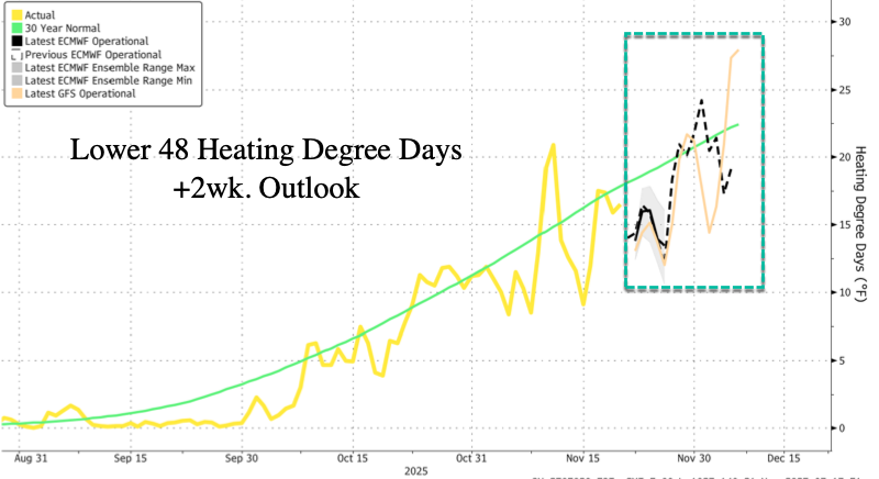
In energy markets, US NatGas futures are up and to the right.

The reason: Lower 48’s Heating Degree Days, a simple weather-based metric used to estimate how much energy people will need to heat homes and buildings, is also up and to the right.
Global warming? Oh, right, that narrative was a big lie by globalists who gave unhinged Democrats talking points and a ‘green’ framework that then pushed climate bills to raid the U.S. Treasury that funneled taxpayer dollars into green companies and climate NGOs.
Tyler Durden
Fri, 11/21/2025 – 08:00ZeroHedge NewsRead More